Glacier Lake Hike
|
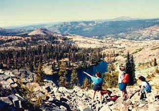
Looking north, down on Glacier Lake from the saddle between two
of the Black Buttes. The highest Black Butte is 8,028 ft. From
this ridge, there is a great 360-degree view of the northern
Sierra and beyond.
This is one of the most convenient and prettiest hikes within easy
driving distance from Sacramento and the Central Valley. A favorite!
|
Looking northeast from the ridge of the Black
Buttes, overlooking Glacier Lake
|
Distance and Difficulty
While my topo software says it's about 3.3 miles one way, it feels
like about 10 miles round trip, from the Grouse Ridge parking lot. There's moderate
elevation gain, maybe 900 ft. There's also the option of another 800-ft. climb
to the top of one of the Black Buttes, overlooking the lake and providing excellent
360-degree views of the surrounding mountains. The trail is good; the climb
up the Black Buttes is cross-country, however, with a little rock-scrambling
likely.
How to get there
Take I-80 east, about 85 miles from
Sacramento, to Highway 20, and turn north toward Grass Valley. 5 or 6
miles along Hwy. 20, turn east on the Bowman Lake Road, for 6 miles.
Just past the PG&E camp, turn south (right) on the Grouse Ridge
Lookout road. The road becomes dirt & gravel. While 4WD isn't
required during the summer, it's good to have a vehicle with
relatively high clearance...lots of potholes, rocks, bumps. In
spring/early summer or after an early snowfall, don't risk it in
anything but 4WD. It will probably take at least 25 min. to drive the
last 6 miles on the dirt road. Keep left, beyond the Grouse Ridge
Campground, to the trailhead parking lot. While one can also park and
hike from Carr Lake, further along the Bowman Lake Road, it adds
another 4 miles round-trip to the hike, and it's not as attractive a
hike. Carr Lake is also often crowded. I recommend using the Grouse
Ridge parking lot as your trailhead.
Rewards
In addition to the beautiful scenery along the
trail, with granite outcroppings, wooded glades and the occasional
mountain meadow, Glacier Lake is a lovely small alpine lake tucked
under the imposing Black Buttes. It's a great place for an
admittedly-chilly swim, clean & clear. If you decide to climb the
Black Buttes, with the frequent good visibility, you'll see peaks
from Mount Diablo to Shasta.
Preparations
Carry 1 to 2 quarts of water, depending on
the temperature. There's almost always running water available in many
little streams, but there are also summer-grazing cows. It's probably
wise to treat even the running water. Carry extra clothing to the
trailhead and decide there how much to put in your daypack. There are
often thunderstorms in the summer, and occasionally late or early
snowfalls. Check the weather before you leave.
Here's a rough map of the hiking route (111 KB).
The old-ish topo map does not indicate the new-ish trail to Glacier Lake, so
I've sketched it. No guarantees this route is absolutely accurate. Here's another
Glacier Lake picture.