Loch Leven Hike
This is one of the best-known hikes along I-80.
We have our own variation on this popular hike, choosing to go cross-country to Upper Loch
Leven, just beyond the top of the ridge, before the trail drops down to the other 2 lakes.
Distance and Difficulty
I'm not sure I
believe my topo software, which says the hike is 6.7 miles round trip. Seems longer to me.
The trail is well-maintained, and the cross-country hiking is easy, through mostly open
terrain. Of course you'll need to pick your way around some marshy or brushy areas, but
there's lots of rambling over granite. You'll have just over 1,900 ft. in elevation gain,
a good work-out.
|
 |
How to Get There
Take I-80 east, about 95 miles from Sacramento, to the Big Bend exit. Turn left on the
frontage road and travel perhaps a mile, past the Ranger Station on the left, to the
parking area for the trailhead. Because this trail gets lots of use, parking can be
difficult. This is a busy road, so if there isn't room in the parking lot, it's worth the
time to find a parking spot along the road that's completely off the pavement.
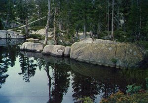
Rewards
While we usually see lots of
people along the trail, we've never seen anyone else on our cross-country route. It's easy
cross-country hiking and fun to explore the nooks and crannies among the granite
outcroppings. The lakes themselves are lovely, even with their heavy use. Middle and Upper
Loch Leven Lakes are great for swimming, if a little nippy for some. Feels great on a hot
day!
Preparations
Carry 1 to 2 quarts of
water, depending on the temperature. There’s often running water in streams along the
trail, but drink at your own risk. It's probably wise to treat even the running water.
Check the area weather before you leave home. There are often thunderstorms in the summer, and occasionally late or early snowfalls. Bring extra clothing to the trailhead and decide at that point what you want carry on your hike.
Map
Here's a rough map of our variation on the Loch
Leven Lakes trail, including our cross-country loop to Upper Loch Leven Lake
and the return by the usual trail. The map isn't exact. Each time we go cross-country,
we choose a slightly different route.